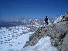
The wildflowers were out in force, and we wound through mountainsides covered in Lupin and Indian Paintbrush. It even took us right in front of a 20-foot waterfall!
The clouds came and went, and thus, so did our views. As we made our way north, toward the Packwood Glacier, we began crossing a few small snowfields, and eventually came to an unmarked junction on a ridge near Mt. Snowy. We had seen a trail runner go left here, and rock cairns went right, although that looked like a summit trail for Mt. Snowy. After consulting a map, we determined that the PCT went straight, which was a scree trail, and the most undefined. The bummer was that the clouds moved in right then, so we were whited out and had very limited visibility. We followed the trail out just above the Packwood Glacier which is not a crevassed glacier, just a lot of snow). Mark said in 2003 all of that was a steep snow field, and we really only had one small section of snow...maybe 100 ft or so.
Just passed the Packwood Glacier is where you get on what is called the Knife's Edge. It's a narrow ridge of trail that you traverse for maybe a mile and a half, cimbing up and down, with steep drop-offs on either side of you. Just s we got there, a guy showed up who had been hiking behind us for a short while. Long story short, he was really confused and lost. He tried telling us that the way we were headed on the PCT was south, and he was convinced we had walked all the way around Old Snowy and were headed south. Mark took the time to take out the map and show him where we were and that we were, in fact, headed north, and in the end, he agreed with us. However, we heard from our friends later that the same guy gave them wrong directions as well and pointed them down the wrong path. Granted, it was fogged in, so he didn't have good visibility, but he was still adamant that he knew where he was.
After that encounter was the Knife's Edge. We were bummed it was foggy, but gla that the wind stayed to a minimum. Others had gone through on their hands and knees in places, and we didn't have anything that bad. We got some cool pictures despite the lack of a view.
We eventually rolled into Lutz Lake, tired from the day and ready for a good nights sleep. After making sure we wouldn't wake up in a puddle if/when it rained, we crashed, glad to be warm and dry once again.
Mark postcard- Lots of rocks; no goats.
Total Miles:2290.3
Miles Today:27.9
Camp 113:Goat Rocks Wilderness
------------------------------
Allow us to help those in need, sell back your spare PocketMail and make some extra pocket money.


No comments:
Post a Comment