Saturday, November 13, 2010

I Think He Missed Me...

Mark was on the campus of Indiana Wesleyan University this past week visiting some friends. There was also a research conference happening, so booths were set up for different veins of ministry and education, Wesley Seminary, being one of them. Apparently, this time around, I was the face of Wesley Seminary:

I still think it's weird to see my face on these signs...

But I also think Mark missed me when he was gone:

A student who knew Mark and I from Heritage Wesleyan Church was walking by and saw Mark taking this picture out of the corner of his eye and thought, "Who's that creepy guy pretending to kiss Jess?" He then took a closer look and realized it wasn't a creepy guy, it was a legitimate kiss from a husband :).

Tuesday, September 28, 2010

The Gift of Friends

A couple of weeks ago we were blessed to have some of our great friends visiting for a week. Steve, Amber, and their son, Lincoln came to visit from Illinois. Steve came out to help us with some sound stuff at the church, but we got the bonus of getting to hang out with them. Julie also was able to come from Colorado, and we had an awesome week together hanging out and just being together. Amber and Julie are two of my best friends from college, and they were also two of my bridesmaids in my wedding. Steve and Mark lived in the same townhouse our senior year of college, and since we don't live near each other, it is always a gift to be able to spend time together in the same place.

I am constantly reminded what a blessing good friends like this are. These friends knew us before we were married and walked through various seasons of life with us. They are people we just get to relax with, laugh with, and "be" with. And while we talk on the phone pretty regularly, getting to spend time together is always refreshing. We spent a lot of time at home hanging out and playing games, but we also got to head out to do a few fun "local" things like Silver Falls State Park and the downtown carousel.


Mark got to hold our purses and Julie's pink phone while we rode the carousel. Doesn't he look good? :)

Julie and I on our horses whose names I've already forgotten. They were something like "moonstar" and "liberty" but I'm not totally sure.

Lincoln and Steve rode a horse that didn't go up and down. I think Lincoln enjoyed it even though he was a little unsure at first.

What a cute family!

This picture makes me happy. It's the "girls" picture by South Falls.

We made the guys take a "boys" picture even though they weren't as gung-ho about it :).

Welcome to Oregon!

What a fun line-up! Steve and Amber made Mark carry Lincoln around as "practice" for some day down the line.

Lincoln "bouldering" with Mark as spotter. He was quite the climber. He practically scaled the booth in a restaurant one night, so this was nothing for him!

So cute!

Julie flew out seven hours later than Steve, Amber, and Lincoln, so we made a quick hop over to the coast at Cannon Beach for the afternoon to do a little hike. This is a crazy zoomed in view of the lighthouse at Cannon Beach.

Yep, that little rock out there is the lighthouse.

At the end of our hike at a viewpoint.

the gorgeous cliffs and rocks that typify the Oregon coast.

I am so thankful for this week we were able to have together. I feel so blessed to have them in my life and to be able to have times where we get to see each other, even when we live halfway across the country. This, combined with seeing Amber and another great friend, Christin, in August, has combined to make for a great few months of connections. I truly feel like the friends God has given me are gifts of grace, and I need these times to remind me to not take them for granted. Thanks, friends, for a fun week. Let's do it again soon!

Monday, September 06, 2010

Mt. Shasta & Lassen Nat'l Park

This past week Mark and I were able to take a Labor Day vacation. Finding an adventure we could pull off while still having internet access took a little time to figure out (apparently online school doesn't stop if you take vacation!). We finally settled on an attempt at climbing Mt. Shasta in northern California and spending some time in Lassen National Park. We were more than lucky; the weather was as good as we could have asked for. And even though we live near sea level, we were able to summit with nothing more than a shortness of breath and a slight headache that went away as we descended. Overall, the climb was amazing and challenging, and it was an awesome week! Here are a few pictures to document our journey...

The view from the pullout on I-5.

The mountain at sunset from the city of Mt. Shasta, CA.

At the trailhead getting our gear ready.

We took the Clear Creek Route up the mountain. The trailhead is at 6500 ft.

Our first steps up to our campsite at 8500 ft. at "the springs."


The view of our route. Obviously it's not exact, but the red line is relatively close to what we walked. We camped by the springs, where are the green patches by the red line lower on the mountain.

Our campsite at 8500 ft. at the springs. It took a little over an hour to hike up to this spot and we were able to scout out our route and talk to a couple people who were on their way down.

We woke up at 4:30am and began hiking around 5:15am. It was still dark but surprisingly warm. We were so thankful that it wasn't frigid and windy! It's never any fun to climb out of your sleeping bag when it's dark and cold :).

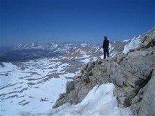
Since we followed a route and not a trail, there were several options of where to go as we went up. There were several "user trails" (trails made by hikers, but not official ones) and we ended up crossing the snow and scrambling up the rock to Mark's right in the picture above. Much of the route was scree (loose rock and sand) so it was nice to have semi-solid footing for awhile!

This was a class 3 scramble and wasn't as steep as it looks in the picture. I was thankful for the rock climbing experience I'd gotten this summer that helped with hand-holds and footing...thanks Danielle!

This was a random rock that we could see even from our camp. It sits at around 12,800 ft. We've heard it called the UFO Rock (because it is sort of randomly dropped on the shoulder of the mountain) and one lady who was on the summit with us called it the Pancake Rock because of the flat layers. I call it the Weird Rock. We stared at this rock for hours and it was so great to finally reach it. That alone felt like an accomplishment!

Of course we didn't take any pictures of the steep scree or snow climbing we did between the Wierd Rock and the summit. It was on the intense side and of course the camera never comes out in those times. This section was the most challenging, but in a good way.

Here I am on the summit! 14,162 ft. We summited around 12:15pm, making the climb a 7 hour journey.

Mark on the summit! A total of 7,662 ft. from the trailhead, and 5,662 ft. for the day.

We decided it was safer to come down a scree chute and not the steep snow we climbed up. Mark is down and out of the way of rock fall, and I am just beginning my plunge-step down the loose rock.

This is the steep scree and rock we had to climb down (and up!) between the Wierd Rock and the summit. It was actually easier going down than up, and I was very glad to reach the Wierd Rock and user trails again!

Mark ended up with a handful of sand and rock in his shoe after that part of the descent!

Descending the user trails and on our way to our campsite and then the car. By the time we got down to the car, my "descending legs" were exhausted! We were so excited to have accomplished our goal, and treated ourselves to a hotel room (instead of camping) so we could crash in an actual bed. I think we were out by 8 or 9:00pm!

Even though the next day was the Friday of Labor Day weekend, we were able to get a campsite at Lassen National Park. The hope was to be able t climb Lassen Peak and to see some of the other volcanic features of the park. This is the view of Lassen Peak from Manzanita Lake Campground.

The trail up Lassen Peak has been closed for repairs for awhile. We had been hoping it would be open (the Park and indicated it might be) by Saturday (the day we were there), but alas, they only opened the first half of the trail. We were able to climb the first 1000 ft. and still get a good view.

We even watched this guy get a ticket for jumping the fence and heading to the summit anyway (he wasn't the only one slapped with a $175 fine for doing this!). Do you like how discreet I was by taking his picture?

The other cool volcanic feature we saw was called Bumpass Hell. There were quite a few thermal pools/lakes, boiling mud holes, and interesting landscapes. The only downside? The sulfur smell :).

The view of Bumpass Hell from the trail.

We were even able to visit our friends Paul and Amanda and their son, Findley, for a couple of days, which was a great conclusion to our week. It was restful, but also a lot of fun to catch up with them and to chase Fin all over the place. He is almost three and full of energy! Paul and Amanda are also great people to hang with after an adventure because they are adventurers themselves. It's always fun to share stories and pictures with people who have done similar things at some point.

It was such a fun, exciting, challenging, and restful week, and I am constantly reminded that difficult tasks just need to be taken one step at a time. Even in the moments when I am nervous or scared, I only have to focus on each step I am taking at the moment, and before I know it, I have reached my goal. I love looking back and knowing I was stretched. This means that I grew in areas I wouldn't have otherwise, and I am reminded that I can do far more than I give myself credit for. It is also a great reminder why it's good to only be able to see so far in front of me. If I truly knew how hard this climb would be or how steep the scree or snow, I might not have even attempted to climb Mt. Shasta in the first place. But because I faced them in the moment, I was able to conquer my fears and reach the summit. Even though it was painful and hurt to walk for several days afterward, it was a reminder of where we'd been and what we'd done. The journey was worth every step.

Saturday, August 28, 2010

Harvest Time

Now is the time for harvest. Here are a few pictures of the veggies that are growing on my plants. I am pretty continually eating cucumbers, zucchini, green beans, and onions from my garden. It's pretty awesome. Here are a few pics of what's growing. Since we lost our camera while kayaking (yes, this should be a post with pictures of us kayaking the North Fork of the Santiam River), I took these pictures on my cell phone - my 5-year-old cell phone :). Sorry if they're a bit blurry!

carrots. notice they aren't as "pretty" as the ones you buy in the store.

onions...I love onions, so I love that I get to grow them! they make my eyes water way more than the ones I buy though!

green peppers. I have red ones, too, but none of them are red yet.

the ever-expanding cucumber vine. we have to work to keep up with these guys!

zucchini. these are MUCH bigger than the ones you buy at the store!

roma tomatoes. I am getting one or two of these at a time. however, my plant has enough tomatoes on it to can bottles and bottles of salsa. if only they would turn red...

big boy tomatoes. i haven't had one red one yet, but there is an abundance of these as well. I can't wait!

Thanks again, Dad for helping me out! Hope you enjoy the update!

Saturday, July 17, 2010

Jefferson Park

On May 17, Mark and I went on a hike toward Jefferson Park, a really beautiful area on the North/Northwest side of Mt. Jefferson. We hiked through there on the PCT, and are excited that there is a trail nearby that will allow us to access it. Everything you read about the hike we did says that the trail is open mid-July to October, so we knew May 17 was really early, but we gave it a try and we were stopped in our tracks by a huge wall of snow that we didn't have the time to really traverse safely. Last week we gave it a go again, and this time, since it truly is mid-July, we had much better luck and were able to hike the full 5.1 miles (10.2 mile round-trip) back into Jefferson Park. Here are a few comparison pictures:

These weren't taken in the exact same spot, but they are in the same general area.

This is the exact spot. Amazing the difference a couple of months can make!

Once again, these aren't the same exact spot, but in the same general area. The drop-off down to the right is pretty steep (even though you can't tell in the picture), so even though we climbed up on top of the snow, we didn't feel comfortable risking it. To fall was to equal major injury. This time we just sailed on through.

And this was our reward! A view of Mt. Jefferson from the trail.

Does the view get much better than this?

The Whitewater Creek Trail connected with the PCT about a mile outside of Jefferson Park. It was so fun to reconnect with our old friend (the PCT). From here into Jefferson Park was about 90 percent snow.

The view from Jefferson Park. We didn't get to stay very long. We basically took a few pictures and turned around and left. It was getting late and we had 5 miles to hike back out. Next time we may try to hike up and camp overnight.

We had to cross Whitewater Creek on our way up and down. There is a "bridge" over the creek, that, as you can tell, is pretty washed out. We were able to make it across on the way up by using a combination of rocks and the "bridge" and then making a big leap onto the snow (hiking poles are awesome helps for times like this!). We knew that hopping onto a snow bridge was much easier than hopping off of a snow bridge (the snow is much more likely to break from the force of hopping off of it). So on the way down, Mark went first, and sure enough, the snow bridge broke as he launched off of it. Luckily he made it safely to the rock, but got a bit of a wet foot in the process. This was fine for him, but left me with a huge gap that I wasn't willing to try to jump over. The circle above is where the snow used to be :). Plan B: ford the ice cold creek.

This is me making my way over to really the only easily accessible place to the water that wasn't a complete snow bridge.

It was about half way through that my feet realized how cold the water was.

This was my "my feet are so cold it's painful" face. I had to hop around, go find sun, and just get hiking again to warm up.

It was super fun, even though I had to walk through ice water :). Next time, I hope we can leave earlier and stay overnight, giving us more time to enjoy the amazing views and gorgeous surroundings! Also, maybe by then the bridge will be fixed :).