
At Kennedy Meadows, the enterance to the High Sierra, we had to pick up our ice axes (in the aptly shaped box in Mark's hands) and our bear barrels...those wonderful black containers that weigh 2.5 lbs empty.

This fire had kept previous hikers from walking through. We heard this part of the trail was okay to walk through, but then we saw this smoke. There were still a few fire fighters around and a few rangers montering it, and a few days later it started back up (after we were long past it, we could see the smoke rising from a ridge behind us).

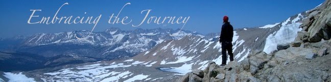
A view from the climb up Mt. Whitney. The lake on the right is named Guitar Lake.

Here we are on the summit of Mt. Whitney, 14,495 ft, the highest point in the lower 48 states.

We were always excited to see a way across the creeks that didn't involve us getting our feet wet, whether it was a bridge, a log, or rock hopping.

Forester Pass is the highest point on the official PCT at 13,200 ft. Mt. Whitney is a side hike.

Mark at Forester Pass.

The Kearsarge Pinnacles.

We did a side hike out over Kearsarge Pass to resupply in Independance, CA. We stayed at a hotel in Bishop, CA, which had a grill we could use. A bunch of us bought some food at a local grocery and Wiz Kid offered to grill it up for us.

Jess postholing (sinking into the soft snow) as she descends Glen Pass.

Climbing up steep Mather Pass. This is the only pass we used our ice axes on.

One of the many incredible views in the Sierras.

I had lasik done a month before we left, so I got to put these wonderful eye drops in 6-8 times a day!

Beside Evolution Lake, just after Muir Pass.

Just after crossing Evolution Creek. It is one of the top two creeks that have the reputation of being the worst crossings. This year, it wasn't too bad. In 2005 when we hiked the JMT, it was roaring white water.

Mark admiring the view from Seldon Pass.

One stop is at Vermillion Valley Resort. There is a ferry that shuttles you across Lake Edison so that you don't have to walk the 5 or so extra miles in. The lake was so low this year that they hadn't gotten the ferry in yet and were using these small fishing boats.

Mark crossing a creek.

One of the best views we had one a break: Lake Virginia. Isn't it postcard-esque?

Snowplant.

For about 14 miles, the PCT and JMT split. The JMT goes down by Shadow Lake, nestled under Banner and Ritter Peaks (shown above).

Thousand Island lake.

Jess and JZ as we head down from Donahue Pass.

All the snow had melted out except this small ridge of snow on the trail. If you slip down the right side, you fall between the snow and the rock; if you slid down the left side, you landed in a white water creek. Luckily it wasn't a long walk!

Crossing the 1000 mile mark!

We camped high on this rocky ridge a few miles short of Sonora Pass. We had to clear a space in the rocks to sleep!

One of our last views of big snowy mountains.

Mark in a field of Mule's Ear flowers.

Aloha Lake in the Desolation Wilderness.

These were some of the wierdest and coolest "flowers" we saw on the trail.

After we hitched around a forest fire, a crew of us ended up sitting on this patch of lawn outside a grocery store for a few hours in Chester, CA.

A boiling Lake in Lassen Volcanic National Park.

The only Mountain Lion we saw on the whole trip was dead and frozen in a locker. A forest service guy offered to show it to us. It had been hit by a car.

Burney Falls in Burney Falls State Park.

One of the many incredible flowers along the way.

Squaw Valley/Creek. (one of two along the way).

This is where Mark ended his hike with Coach in 2003. We had to hitch at the on-ramp to I-5 to get to Mt. Shasta (the city).

Castle Crags State Park.

Oh, my wonderful heat rash. We figured out later that it was from my pants that had a chemical in them called Buzz Off that was an insect repellant. It worked pretty well at keeping away bugs, but when it was hot out, gave me a rash all over my legs.

It wasn't very often we had to sleep on the trail, but this day we had hiked 32 miles to a spring and were dead tired. So, up the tents went on the trail. As you can see, it's not the best campsite ever.

This is Billy Goat. He is a famous hiker, who lives on the trail nearly year round. He is retired and loves hiking so much, he finds trails to hike most of the year. The LA times featured an article on him. To read, click
here.
This is what most of northern California looked like...smokey haze from all the forest fires.

We hadn't seen snow for awhile, and then we came around a corner to see this big pile of snow!

A great old car in Etna, CA. We figured it was just an old car sitting around, and later we saw it driving around town!

We ran into some cavers who took us into this cave near Marble Valley.

This was the worst day of smoke on the whole trail. We walked with bandanas over our faces for awhile. We were pretty much whited-out for a good chunk of the day.

We would often wash out our shirts, socks, etc in creeks when we could...especially if it was hot out. Mark actually dove into this creek...it was VERY cold water! Notice the great hiker tan he has on his arms and legs!

A view at the top of the incredibley long climb out of Seiad Valley, CA.

In Northern CA we would often come across cows. Not sure how it all works, but ranchers let their cows wander and graze in the mountains. Unfortunately, it meant that the water sources were often contaminated by cow pies...one good reason to treat your water! We skipped those ones if possible.
 At Kennedy Meadows, the enterance to the High Sierra, we had to pick up our ice axes (in the aptly shaped box in Mark's hands) and our bear barrels...those wonderful black containers that weigh 2.5 lbs empty.
 This fire had kept previous hikers from walking through. We heard this part of the trail was okay to walk through, but then we saw this smoke. There were still a few fire fighters around and a few rangers montering it, and a few days later it started back up (after we were long past it, we could see the smoke rising from a ridge behind us).
 A view from the climb up Mt. Whitney. The lake on the right is named Guitar Lake.
 Here we are on the summit of Mt. Whitney, 14,495 ft, the highest point in the lower 48 states.
 We were always excited to see a way across the creeks that didn't involve us getting our feet wet, whether it was a bridge, a log, or rock hopping.
 Forester Pass is the highest point on the official PCT at 13,200 ft. Mt. Whitney is a side hike.
 Mark at Forester Pass.
 The Kearsarge Pinnacles.
 We did a side hike out over Kearsarge Pass to resupply in Independance, CA. We stayed at a hotel in Bishop, CA, which had a grill we could use. A bunch of us bought some food at a local grocery and Wiz Kid offered to grill it up for us.
 Jess postholing (sinking into the soft snow) as she descends Glen Pass.
 Climbing up steep Mather Pass. This is the only pass we used our ice axes on.
 One of the many incredible views in the Sierras.
 I had lasik done a month before we left, so I got to put these wonderful eye drops in 6-8 times a day!
 Beside Evolution Lake, just after Muir Pass.
 Just after crossing Evolution Creek. It is one of the top two creeks that have the reputation of being the worst crossings. This year, it wasn't too bad. In 2005 when we hiked the JMT, it was roaring white water.
 Mark admiring the view from Seldon Pass.
 One stop is at Vermillion Valley Resort. There is a ferry that shuttles you across Lake Edison so that you don't have to walk the 5 or so extra miles in. The lake was so low this year that they hadn't gotten the ferry in yet and were using these small fishing boats.
 Mark crossing a creek.
 One of the best views we had one a break: Lake Virginia. Isn't it postcard-esque?
 Snowplant.
 For about 14 miles, the PCT and JMT split. The JMT goes down by Shadow Lake, nestled under Banner and Ritter Peaks (shown above).
 Thousand Island lake.
 Jess and JZ as we head down from Donahue Pass.
 All the snow had melted out except this small ridge of snow on the trail. If you slip down the right side, you fall between the snow and the rock; if you slid down the left side, you landed in a white water creek. Luckily it wasn't a long walk!
 Crossing the 1000 mile mark!
 We camped high on this rocky ridge a few miles short of Sonora Pass. We had to clear a space in the rocks to sleep!
 One of our last views of big snowy mountains.
 Mark in a field of Mule's Ear flowers.
 Aloha Lake in the Desolation Wilderness.
 These were some of the wierdest and coolest "flowers" we saw on the trail.
 After we hitched around a forest fire, a crew of us ended up sitting on this patch of lawn outside a grocery store for a few hours in Chester, CA.
 A boiling Lake in Lassen Volcanic National Park.
 The only Mountain Lion we saw on the whole trip was dead and frozen in a locker. A forest service guy offered to show it to us. It had been hit by a car.
 Burney Falls in Burney Falls State Park.
 One of the many incredible flowers along the way.
 Squaw Valley/Creek. (one of two along the way).
 This is where Mark ended his hike with Coach in 2003. We had to hitch at the on-ramp to I-5 to get to Mt. Shasta (the city).
 Castle Crags State Park.
 Oh, my wonderful heat rash. We figured out later that it was from my pants that had a chemical in them called Buzz Off that was an insect repellant. It worked pretty well at keeping away bugs, but when it was hot out, gave me a rash all over my legs.
 It wasn't very often we had to sleep on the trail, but this day we had hiked 32 miles to a spring and were dead tired. So, up the tents went on the trail. As you can see, it's not the best campsite ever.
 This is Billy Goat. He is a famous hiker, who lives on the trail nearly year round. He is retired and loves hiking so much, he finds trails to hike most of the year. The LA times featured an article on him. To read, click here.
 This is what most of northern California looked like...smokey haze from all the forest fires.
 We hadn't seen snow for awhile, and then we came around a corner to see this big pile of snow!
 A great old car in Etna, CA. We figured it was just an old car sitting around, and later we saw it driving around town!
 We ran into some cavers who took us into this cave near Marble Valley.
 This was the worst day of smoke on the whole trail. We walked with bandanas over our faces for awhile. We were pretty much whited-out for a good chunk of the day.
 We would often wash out our shirts, socks, etc in creeks when we could...especially if it was hot out. Mark actually dove into this creek...it was VERY cold water! Notice the great hiker tan he has on his arms and legs!
 A view at the top of the incredibley long climb out of Seiad Valley, CA.
 In Northern CA we would often come across cows. Not sure how it all works, but ranchers let their cows wander and graze in the mountains. Unfortunately, it meant that the water sources were often contaminated by cow pies...one good reason to treat your water! We skipped those ones if possible.
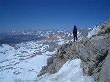

2 comments:
Thanks for sharing the pics. Unreal. Stop tempting everyone!
I have never climbed anything close to a real mountain, but I just spent the last five weeks sleeping at 13,300 ft in Bolivia, glancing out at 18K, 21K+ peaks that didn't seem so out of reach. Maybe someday...
THANKS for all the work you did loading these!!!! I had a wonderful time running through them again! (the first time last week on my TV with you in real life! Thanks!
Post a Comment